
The Dolomites: Nature’s Greatest Masterpiece
- Izabel Stalder

- Aug 12, 2025
- 30 min read
Updated: Jan 5

The Dolomites had lived in my imagination long before I ever set foot there. That dramatic skyline of jagged peaks, misty sunrises, and mirror-like lakes felt like something out of a storybook I kept returning to — always just out of reach. And even though they’re not far from Switzerland, where we live, I’ve learned that sometimes the places closest to us are the ones that take the longest to finally visit.
But maybe that’s how it was meant to be. Because when we did finally go — at the beginning of July — it felt like perfect timing. Just before the crowds flood in, just as the wildflowers bloom, and just when the mountain air is warm enough to hike in but crisp enough to still carry silence.

Our five-day journey through this UNESCO World Heritage site was one of those trips that doesn’t leave you. Not when the clouds wrap around a cliff at sunrise, not when you hear marmots squeaking between the rocks, and definitely not when you’re standing at the edge of a turquoise lake with no sound but the wind and your own breath.
This time was extra special — we met up with a couple we’re very close to, our dear friends from Bulgaria, and spent these days chasing views, early mornings, and slow moments together. They were traveling by camper van (more on that later), while we came by car from Switzerland — and for a few days, our paths aligned perfectly.
We’ll never forget the 4 am club hikes — our little name for the sunrise missions. Waking up in complete darkness, hiking through moody, shifting weather, and watching the peaks turn pink as the sun crawled over the Alps. There’s something in that silence that grounds you.
We were quite lucky with the weather, but the Dolomites are wild and unpredictable — that’s part of the magic, and part of the challenge. This is not the easiest destination to explore unless you’ve done your research. And that’s why I created this blog post — to share our exact itinerary, favourite spots, and the key tips you should know before going.
Whether you’re planning a hike, a road trip, a luxury hotel escape, or a camper van adventure — I’ve got you. Here’s everything you need to know.

GENERAL INFORMATION

The Dolomites aren’t just mountains — they feel like something out of a fairytale. Towering limestone peaks, alpine meadows, rolling green valleys, fairytale villages, mirror-like lakes, and sky-piercing cliffs that if you are lucky to have good weather turn pink at sunset (a phenomenon called enrosadira).
Located in the eastern Italian Alps, they span from South Tyrol to Trentino and into Belluno — a place where Italian and Austrian culture blend effortlessly. You’ll see signs in both languages, menus with gnocchi and schnitzel, and people speaking German, Italian, and Ladin.
But the real story? These cliffs were once ancient coral reefs, millions of years ago, submerged under the sea. The sea retreated, the Earth shifted, and now we get to walk on the remnants of prehistoric ocean floors, high in the sky.
Location: Northern Italy, primarily in the regions of South Tyrol (Alto Adige), Trentino, and Belluno, stretching into Austria.
Eastern Dolomites: Tre Cime, Lago di Braies, Passo Giau, Lago di Misurina, Lago di Sorapiss, Cinque Torri, Lago di Dobbiaco
Western Dolomites: Val Gardena, Passo Gardena, Seceda, Alpe di Siusi (Seiser Alm)
Etymology: Named after French geologist Déodat de Dolomieu, who studied the area’s unique limestone rock.
Size: About 15,900 km² (6,140 mi²)
Symbol of the Dolomites: The Tre Cime di Lavaredo (Three Peaks)
Population (Italy / Dolomites): Italy: ~59 million / Dolomites: ~600,000 across the mountain region
Languages in the Dolomites: Italian, German, and Ladin (an ancient Rhaeto-Romance language still spoken in valleys like Val Gardena)
Dictionary:Hi – Ciao / Hallo
Thank you – Grazie / Danke
How are you? – Come stai? / Wie geht’s?
The bill, please – Il conto, per favore / Die Rechnung, bitte
Currency: Euro (€). For reference: 1 EUR = 1.17 USD.
Local time: Central European Time (CET)
Economy: Tourism, alpine agriculture, local artisanal goods, and winter sports
Best time to visit: For hiking late June–early July and early September are ideal. Avoid late July–August if you can — the roads are packed, accommodations are overbooked, and even the smallest trails get crowded.
What to pack: Layers, hiking shoes, light rain jacket, reusable water bottle, sunscreen, sunglasses, hat, trekking poles (optional – we didn’t use any), and cash (some huts don’t accept cards).

Electricity plug: Type F plugs (two round pins with side grounding clips) at 230V, matching mainland Europe's standard. Plugs from most European countries (like Type C or E) will work directly, but travellers from the UK, US, Canada, or Australia will need a Type F adapter.
Food culture in the Dolomites: One of the best surprises? The food. A fusion of Alpine tradition and Italian soul. Expect hearty mountain dishes with elegant touches — from creamy polenta to rich mushroom ragù, fluffy knödel dumplings, apple strudel, fresh berries, and herbal teas from local meadows.
Staple ingredients: Polenta, speck (cured ham), mushrooms, barley, potatoes, wild herbs, alpine cheeses, apples, fresh dairy.
Typical foods:
Canederli: bread dumplings
Schlutzkrapfen: spinach ravioli
Kaiserschmarrn: fluffy shredded pancakes
Barley soup
Grilled vegetables
Berry desserts
Travel requirements: EU citizens can enter freely; for others, a Schengen visa might be required. No vaccinations or health forms are currently necessary.
HOW TO GET AROUND
We drove from Switzerland, but if you’re flying in, the closest airports are:
Innsbruck (Austria) – ~1.5h to Val Gardena
Venice – ~2h to Cortina d’Ampezzo
Verona – ~2.5h
Munich (Germany) – ~3.5–4h

Renting a car is the easiest way to explore the Dolomites at your own pace. BUT:Many popular roads are restricted from 9:00 am–5:00 pm in summer (like the Lago di Braiesa, Alpe di Siusi or Tre Cime di Lavaredo road). You either need to go early in the morning, take a shuttle, or walk from further away. These measures are meant to protect nature and manage traffic.
💡 Make sure to check all vignette (road toll) requirements if you’re driving through nearby countries. For example, when we passed through Austria, we bought our vignette online from the official website asfinag.at, and in addition, there are digital section tolls for certain tunnels and high alpine roads that must be paid separately. Always check your route in advance to avoid surprises or fines.
Transportation and road tips:
Public transport: Trains run to larger hubs (e.g., Bolzano), with local buses to towns and trailheads
Shuttles: Available for major sights like Lago di Braies, Seiser Alm, and Tre Cime
Cycling: Hugely popular, especially in summer — expect lots of road cyclists
Taxis: Rare and expensive — don’t rely on them
Camper vans and parking:
Our friends were traveling with their camper van, which is a wonderful way to see the Dolomites — but wild camping is not allowed.
You must stay in:
Official camper sites
Campsites with services
Reserved lots (often need to be booked in advance during peak season)Some valleys allow overnight stays in designated lots, but always check local signs — rules are enforced.
DAY-BY-DAY ITINERARY

Before diving into each day, let me take you into the rhythm of our trip. The Dolomites have a way of pulling you into their magic — one sunrise at a time, one winding pass after another, one lake so still it feels like time has stopped.
Our itinerary was a blend of those big, must‑see moments and the little unplanned ones that end up meaning just as much. The first two days we explored the eastern Dolomites, with iconic spots like Tre Cime di Lavaredo and Lago di Braies setting the tone. Then we shifted west, spending the next two days in the western Dolomites – wandering through places like Seceda, Alpe di Siusi, and Val Gardena.
Some mornings started before the sun, chasing that first light over jagged peaks. Other times, we lingered over coffee, letting the mountains decide what the day would bring.
Here’s how our journey unfolded — day by day, trail by trail, memory by memory.
DAY 1.
We left Switzerland around 7 am. It was a long drive, but filled with excitement—we couldn’t wait to finally explore this place we’d dreamed about for so long.
After winding through northern Italy’s increasingly dramatic landscapes, we arrived in the Dolomites early afternoon.

CINQUE TORRI
Our first destination: Cinque Torri—a rugged and iconic formation of five limestone towers rising at around 2,250 meters. Not just a geological wonder, this area is also a piece of living history: during World War I, it was part of the Italian front line, and traces of military life remain frozen in time among the rocks.
Since the chairlift (Seggiovia Cinque Torri) runs only from 8:30 AM to 5:00 PM, and we had a packed schedule, we decided to take it rather than hike. We parked right by the base station—free parking, super convenient.
🎫 The round-trip lift ticket was 25 EUR, and you can buy them online in advance here.
⏱ Cable car opening times: 8 am – 5 pm
🅿 Free parking on site
As much as it would’ve been nice to do the hiking, this time-saving shortcut was the right call.
Got time? Here are your hiking options to reach Cinque Torri on foot:
ᨒ HIKING ROUTES
If you want to skip the lift, there are two main hiking routes:
Trail under the chairlift
The shortest but steepest way up—about 1.8 km with ~365 meters elevation gain. Moderate to hard.
Trail via Rifugio Cinque Torri
A longer but more scenic path (approx. 2.5 km one way). It gently weaves through forest and gravel road, with sections of paved trail. Easier and more scenic overall.Both trails lead to the top area near Rifugio Scoiattoli, and the experience is rewarding either way.
💡 Note: If you visit before June 21st, when the rifugi officially open, there’s a small chance you may be allowed to drive further up and park closer near Rifugio Cinque Torri, but that access closes once the summer season starts.
Shortly after arriving at the top, we were greeted by a sudden burst of mountain weather—a classic Dolomites summer downpour. We took refuge at Rifugio Scoiattoli, tucked in with a warm drink and a snack while the clouds passed. There’s something extra cozy about alpine huts in the rain.
Once the rain passed, we headed out on the Cinque Torri loop—an easy, scenic trail that weaves through meadows and wraps around the limestone towers.
Distance: approx. 2 km, almost no elevation gain. What makes it special isn’t just the views (which are breathtaking) but the open-air WWI museum, with trenches, tunnels, and lookout points offering insight into life on the frontlines. History and nature merge in such a powerful way here.
Before leaving, make sure to have a quick stop at Lago Bai de Dones, right at the base of the chairlift. It’s a small but beautifully reflective lake—worth walking around if you have time.


CINQUE TORRI - PASSO GIAU - approx. 19 km

PASSO GIAU
In the late afternoon, we took the SP638 Serpentine Road up to Passo Giau, one of the most stunning and photogenic mountain passes in the Dolomites. The drive itself is an experience—each bend reveals new jagged ridges, rolling alpine meadows, and cinematic elevation changes.
At 2,236 meters, the Parcheggio Passo Giau offers free parking and easy access to panoramic views. While the serpentine road below was cloaked in moody clouds and dramatic light shifts, the top of the pass was basked in a more serene and sunny atmosphere. As we stepped out of the car, the sun pierced through the cloud ceiling, lighting up the meadows in a soft golden glow.

From the pass, you can see iconic summits like Ra Gusela, a sharp, triangular peak that dominates the skyline to the south, and Monte Nuvolau, home to one of the oldest mountain huts in the Dolomites. To the west, the peaks of Averau rise steeply, and to the east, you can trace the outlines of Tofane and Lastoni di Formin.
Alpine cows grazed in the pastures, bells gently echoing through the crisp air. It was the kind of landscape that makes you pause without needing a reason.
If you’re into drone photography or just want to take in one of the best viewpoints in the region, here’s the exact spot we used for an aerial shot:
⚲ 46.50166° N, 12.07535° E


PASSO GIAU - CORTINA D’AMPEZZO - approx. 18 km
CORTINA D’AMPEZZO
After soaking in the peace and beauty of Passo Giau, we descended toward Cortina d’Ampezzo—often called the Queen of the Dolomites. This upscale mountain town is known for its luxury alpine charm, designer boutiques, elegant promenades, and glamorous ski history (including hosting the 1956 Winter Olympics). It’s a favourite of Italian elites and international visitors alike, and it sits in a spectacular natural amphitheatre of peaks.
Even just passing through is worth it—Cortina balances refined elegance with outdoor adventure energy.
CORTINA D’AMPEZZO - LAGO DI LANDRO - approx. 21 km
LAGO DI LANDRO (DÜRRENSEE)
On the way to the hotel we stopped at Lago di Landro, a peaceful alpine lake just off the main road. Its calm, glacial blue waters mirror the Cristallo massif, creating perfect symmetry on a windless day. The lake sits in a wide, open valley surrounded by dramatic peaks. We paused here for a peaceful moment—no crowds, no rush—just crisp mountain air and alpine serenity.


LAGO DI LANDRO - SAN CANDIDO - approx. 17 km
WHERE TO STAY
NATURHOTEL LEITLHOF
For our first two nights, we stayed at the beautiful Naturhotel Leitlhof in San Candido—perfectly located for exploring the eastern Dolomites, including Tre Cime di Lavaredo and Lago di Braies. It easily exceeded our expectations.
The hotel is all about the details: we had a designated table for breakfast and dinner with mountain views, and I was so grateful for the thoughtful vegan meal options. Everything from the fresh local ingredients to the wine list and dessert course felt curated with love. The spa area was a dream—featuring a Bio Sauna, Swiss Pine Sauna, Finnish Sauna, Steam Bath, 40° Onsen Pool, Whirlpool, and both heated indoor and outdoor pools, all overlooking the striking Haunold mountain.
We stayed in the Natura Room, a modern, light-filled space with stone pine elements, a cozy double bed, and a private balcony with stunning alpine views.
After a long day on the road and in the mountains, it was time for a hot shower, a nourishing dinner, and an early bedtime. Our alarms were already set for our first 4 am sunrise mission the next day.
Instagram: @naturhotel_leitlhof
Book here: Naturhotel Leitlhof


DAY 2.
SAN CANDIDO - TRE CIME DI LAVAREDO - approx. 31 km
TRE CIME DI LAVAREDO
We woke up a bit after 3 am, eyes heavy but spirits high. It was time for our most anticipated sunrise mission—the kind we lovingly call a 4 am club hike. This time, we were joined by our close friends Anna and Zhivko, who had arrived the night before with their camper van and were already waiting for us at Parcheggio Auronzo, the closest official parking spot to the Tre Cime di Lavaredo trailhead.
We had pre-booked our 12-hour parking slot online via the official portal, which is a must during the high season. The cost was €40 for a car, and €60 for camper vans. If you’re planning a visit, make sure to book as early as possible—spots fill up fast. Though the toll road leading up to Rifugio Auronzo is closed to general access most of the time, if you’ve pre-purchased a parking pass, the automated system scans your license plate and allows you to enter for the booked time.
We parked at 2,333 meters altitude, where the air already felt thinner and the surrounding silhouettes hinted at the majesty waiting for the sun to rise up. The weather had been rough during the night, with storms and strong winds, but by the time we arrived, the sky had started to clear and the ground was surprisingly dry—though we still dressed in layers and brought our torches for the trail.
Before we dive into our experience, here’s some background and tips you need to know: The Tre Cime di Lavaredo (or “Three Peaks of Lavaredo”) are more than just mountains — they’re icons. Towering above the surrounding landscapes in sharp vertical slabs, these three limestone pinnacles form the most recognized silhouette in the entire Dolomite range.
Located within the Parco Naturale Tre Cime, they rise to the sky in a stunning trio:
Cima Grande (2,999 m) — the tallest
Cima Ovest (2,973 m)
Cima Piccola (2,857 m)
This area became a UNESCO World Heritage Site in 2009 not only for its geology, but also its cultural significance. During World War I, these rugged peaks were the site of fierce battles between the Italian and Austro-Hungarian armies. Today, hikers walk the same trails once used as military posts—now peaceful, scenic, and hauntingly beautiful.
💡 If you’re planning to visit during the peak season when the road is open (late June to early September), you must book your parking or shuttle far in advance. The access road is gated, and you’ll be turned around if you haven’t reserved.
If you’ve pre-booked your ticket online, the automatic toll gate will recognize your license plate and let you through for your timing slot—even in the early morning hours.
Arriving by car / camper van:
Book your parking here: Parcheggio Tre Cime di Lavaredo
€40 for a car
€60 for a camper van
Parking is valid for 12 hours
Select your arrival time in advance — they are strict
Shuttle alternative (Bus 444):
Book here: Drei-Zinnen
From €16 round-trip
From Dobbiaco to Rifugio Auronzo
Runs May 31 – October 12
Bookings and return times must be made in advance
Rifugio Auronzo is the gateway for both hikes we did.

CADINI DI MISURINA
his was our sunrise mission—our torches lighting the path through alpine stillness. We layered up (it’s always cold before sunrise), met our friends by their camper, and set off quietly into the dark.
ᨒ TRAIL INFO
Start point: Rifugio Auronzo
Do NOT take the main Tre Cime trail — instead, go to the right to trail #117
Distance: ~3.2 km out and back
Difficulty: Moderate (but not suitable for those afraid of heights)
Elevation gain: ~210 m
Time: ~1 hour round trip (excluding time at viewpoint)
From Rifugio Auronzo, cross the road to the large terrace viewpoint overlooking the valley. Most hikers turn left here toward the well-marked Tre Cime di Lavaredo trailhead—but that’s not the way you want to go. Instead, turn right along the terrace. Just a few steps after the terrace ends, you’ll spot a trail sign and a grassy path heading downhill. This is the start of the Cadini di Misurina hike. Follow trail #117 in the direction of Rifugio Col De Varda for one of the most breathtaking viewpoints in the Dolomites.
The hike is relatively short and easy—about 3.2 km round trip, with only ~210 m of elevation gain. That said, it’s not suitable for those with a fear of heights. The path becomes narrow and steep in parts, with exposed drop-offs on one side and little room for error. In wet or icy conditions, it can be slippery and risky, so caution is essential.
Luckily for us, the ground was dry and the skies were beginning to open up. We stood at the edge of the viewpoint, mesmerized by the jagged, surreal ridges glowing under the early morning light. It was one of those moments you lock in your memory forever.
That morning, the sunrise was gentle and shy, appearing through a sky that had seemed so stormy the night before. The trail was dry, the wind soft. The air felt thin and full of magic.
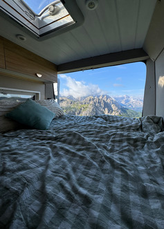
VAN LIFE BREAK
After hiking back, we sat with Anna and Zhivko in their camper van. Their setup was so cozy—bed views facing the mountains, everything arranged with care and love. Anna made us matcha lattes and fresh smoothies, and we laughed like only close friends do. It was one of those slow, quiet travel moments that stay with you longer than the most epic view.
Instagram: @bohoadvantures
Book here: bohoadvantures


TRE CIME
Once refueled, we started our second hike of the day — the full loop trail around Tre Cime di Lavaredo.
ᨒ TRAIL INFO
Start: Rifugio Auronzo
Distance: ~10.3 km loop
Elevation gain: ~400 m
Difficulty: Moderate
Duration: 2.5–4.5 hours depending on stops
Recommended direction: Clockwise (for better light/views); trail #101

The hike begins right from Rifugio Auronzo and forms a loop that circles around the base of the Three Peaks—the tallest of which, Cima Grande, stands at 2,999 meters. We recommend hiking the loop clockwise to gradually build up to the most impressive views.
At the beginning of the trail, we passed a “drone graveyard”—a post covered with broken drones, left there as a warning. It’s a visual reminder that flying drones in this area is prohibited. Not only is it incredibly easy to lose connection in the mountains due to GPS interference or sudden gusts of wind, but many drones crash and fall into hard-to-reach places. When that happens, the lithium batteries they carry pose a serious environmental threat, slowly leaking harmful substances into this fragile alpine ecosystem. Even more importantly, drones disturb wildlife, especially nesting birds and sensitive alpine species, who rely on peace and silence to survive in these high-altitude habitats.
The full loop is 10 km, with approximately 400 m of elevation gain, and is rated moderate in difficulty. It typically takes 3.5–4.5 hours, depending on how often you stop for photos or rest. Along the way, the trail passes several scenic rifugi: Rifugio Lavaredo, Forcella Lavaredo, Rifugio Locatelli, and Malga Langalm. Each offers a unique view of the Three Peaks, from different angles and under different light.
Along the way, we spotted marmots darting through the rocks, and passed tiny glacial pools that many refer to as “lakes,” even though they’re often just meltwater ponds. Still, on a calm day, they reflect the towering peaks perfectly—mirror images of the Dolomites in all their jagged glory.
There’s also a Via Ferrata route in this area, a protected climbing path for more experienced adventurers with harnesses and helmets. Even if you’re not doing it yourself, it’s fascinating to watch climbers navigate the dramatic vertical walls of the peaks.


TRE CIME DI LAVAREDO - LAGO DI MISURINA - approx. 7 km
LAGO DI MISURINA (MISURINASEE)
After saying goodbye to our friends (until the next morning), we began the drive down from Rifugio Auronzo, the air already heavy with the promise of rain. On the way, we made a brief stop at Lago di Misurina (Misurinasee) — the largest natural lake in the Cadore area, often called the “Pearl of the Dolomites.” Nestled at about 1,754 meters above sea level, this stunning lake is famous for its crystal-clear, emerald waters and the dramatic backdrop of the Sorapiss and Cristallo mountain groups.
There’s a well-marked loop trail around the lake, about 2.6 kilometers long, which offers peaceful walks and plenty of photo spots. The path is fairly easy and suitable for all levels, making it a perfect quick stop or gentle stroll. From the far side of the lake, you get a spectacular view of the towering peaks rising sharply above, a true classic Dolomites scene that captures the region’s rugged beauty.
Close by, we also paused to admire a group of beautiful horses grazing freely against this breathtaking mountain backdrop — a simple yet moving scene that felt straight out of an idyllic dream.


We continued our descent just in time to dodge the weather. Storm clouds thickened, and within an hour, a huge thunderstorm swept across the valley, the kind that makes you grateful for shelter and warm food.
Luckily, we had a peaceful afternoon planned at the spa. After the intense hikes and ever-changing weather, it was exactly what we needed. It was the perfect way to unwind, letting our bodies rest and our minds replay all the wonder of the day.
Tomorrow, another exciting day awaited us—but tonight, it was all about good food, great wine, and warm beds.
WHAT WE WOULD’VE DONE DIFFERENTLY (OR ADDED TO OUR ITINERARY IN THE EASTERN DOLOMITES)
LAGO DI SORAPIS
If we had just one more day in the Dolomites, or even one free, clear morning, there’s a hike we would have loved to fit in: Lago di Sorapis (1,923 m). It’s located in the same area we explored the first two days, making it easy to add to a Dolomites itinerary if you have time.
Often described as one of the most beautiful lakes in the Dolomites, Lago di Sorapis is famous for its milky‑turquoise waters — a surreal colour caused by glacial silt suspended in the water. The lake is surrounded by the jagged spires of Punta Sorapis (3,205 m). Even from photos, it’s clear why so many hikers call this a bucket‑list destination.
ᨒ TRAIL INFO
Max Altitude: 1,950 m
Distance: 13.2 km round trip
Elevation Gain: ~460 m
Hike Time: 4–4.5 hours
Difficulty: Moderate to Difficult
The trail is narrow and steep in parts, with cliff‑side sections that can be challenging to pass once people are coming in the opposite direction. That’s why many recommend starting early in the morning — in the morning rush, everyone is heading toward the lake, which makes things easier.
Once you reach Lago di Sorapis, you can wander along sections of the shore to find different viewpoints and angles. While there’s no perfectly flat “loop path,” parts of the shoreline are accessible and worth exploring — just be mindful of mud and uneven rocks, especially after rain.
We didn’t get the chance to do it on this trip. The day we might have fit it in we already had an early‑morning plan for one of the Dolomites’ most iconic spots: Lago di Braies.
If I could change one thing about our Dolomites itinerary, I would:
Add one extra day just for this hike.
Or, if pressed for time, try for an afternoon start on a clear, dry day.
LAGO DI DOBBIACO (TOBLACHER SEE)
Another lake we would have loved to explore in this part of the Dolomites is Lago di Dobbiaco (Toblacher See) — a serene emerald‑blue gem sitting at 1,259 m in the picturesque Val di Landro (Höhlensteintal), often called the “Gateway to the Dolomites” in eastern South Tyrol. This peaceful lake lies in a glacial basin formed during the last Ice Age, when retreating ice carved out the valley and left behind this sparkling pool of water.
Locals, however, like to tell a more romantic story. They say the lake was not carved by ice at all, but born from the tears of a sleeping giant who rests in the mountains above. Legend has it that he fell deeply in love with a woman from a nearby village but was never able to be with her. His grief still trickles down the slopes, filling the lake drop by drop. On calm days, they say you can almost feel his quiet sorrow in the stillness of the water.
ᨒ TRAIL INFO
Max Altitude: ~1,259 m
Distance: ~2.5 km loop
Elevation Gain: Minimal
Hike Time: ~30–45 minutes at a leisurely pace
Difficulty: Easy
The loop trail around the lake is gentle and scenic, mixing forest paths with wooden boardwalks that bring you right to the water’s edge. Many suggest starting on the eastern shore and walking counter‑clockwise, especially in the late afternoon, so you can watch the sunlight set the surrounding peaks aglow before it slips behind the mountains.
One thing’s for sure: Lago di Sorapis and Lago di Dobbiaco are calling us back — and next time, we’ll be answering.
DAY 3.
SAN CANDIDO - LAGO DI BRAIES - approx. 21 km
We woke up to the soft patter of rain, that kind of sleepy morning drizzle that makes you want to stay wrapped in the duvet a bit longer. We had breakfast, slowly sipped our coffee, and left later than planned—it felt like the sky was holding its breath. But I kept refreshing Il Meteo, the Italian weather app I’d downloaded, and just like the previous days, it gave me hope: clear skies after 8 am. I decided to visualize good weather and trust it. We were on our way to one of those places that has danced in my dreams for years—Lago di Braies.
LAGO DI BRAIES (PRAGSER WILDSEE)
⚲ Located at 1,496 meters in the Braies Valley.

As we drove through misty forests and winding alpine roads, the clouds began to lift, and by the time we reached the lake, the world had transformed. The emerald water was still like glass, reflecting the jagged peaks and streaks of drifting clouds like a living painting. It’s the kind of place where you instinctively speak in whispers, just to not break the magic.
We met Anna and Zhivko by the lake—they had slept there in their camper van. However, Anna wasn’t up for the boat ride, as she felt the weather still seemed too unpredictable. So Nico and I decided to go ahead and do the boat tour alone, while they relaxed nearby.
We made our way to the famous wooden boathouse, perched dreamily on the lake’s edge. The picturesque dock that so often stars in photos is actually private—but you can access it during the season (May to November) by renting a traditional rowboat.
Booking: We chose the private boat (€55 for 45 minutes, max 5 people), which also came with two little souvenir magnets. Shared boats cost €15 per person for the same amount of time. No online bookings are available, so get there early—queues can be long, and you’ll miss the best light. And just a heads-up: you’re the captain, so if you’re not comfortable rowing, consider the shared option!
⏱ The boathouse opens at 8:30 am, but earlier slots are often reserved for photo shoots or weddings. We were lucky to witness one—an intimate ceremony unfolding on the dock with delicate mist swirling around the couple. The moodiness of the morning weather made it feel even more ethereal.
We rowed around the lake, giggling at our lack of coordination and admiring the sharp peaks above, including Croda del Becco (2,810 m) rising majestically behind the lake. If boats aren’t your thing, the loop trail around the lake is also wonderful—flat, easy, and takes about 1–1.5 hours.
🚫 Swimming is prohibited in Lago di Braies to preserve its delicate ecosystem.
💡 Important access info: From July 10 to September 10, the Pragser Tal Valley is closed to private vehicles between 9:30 am and 4:00 pm, unless you have an online reservation or transit permit. Reserve in advance if you’re coming during this window.
🅿 Parking:
All parking lots except P1 are within walking distance.
P4 is the closest, but also the most expensive.
I recommend P3—it’s directly next to P4 and offers nearly the same walking distance to the lake at a better rate.
When we left mid-morning, cars were already queuing up the road, so definitely go early!


LAGO DI BRAIES - SANTA MADDALENA - approx. 82 km
After the lake, we met up again with Anna and Zhivko for lunch, catching up and laughing over pizza before setting off together toward the western Dolomites and another postcard-perfect location: Val di Funes and Santa Maddalena.

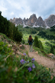
VAL DI FUNES | SANTA MADDALENA
This is one of those valleys that seems too perfect to be real—green meadows, tiny churches, and the jagged Odle (Geisler) peaks rising straight into the sky like something from a storybook. We parked in the small lot at the edge of the village and took the short 10–15 minute walk to the famous panoramic viewpoint of the Church of Santa Maddalena. It’s an easy stroll and totally worth it.
From the hill, you get that classic view—the little white church dwarfed by the dramatic Dolomiti skyline. It’s especially magical in the late afternoon when the light casts long shadows and highlights the contours of the landscape. If you have more time, there are several longer hiking trails in the area too.


SANTA MADDALENA - ORTISEI - approx. 33 km
ORTISEI
WHERE TO STAY
SMART HOTEL SASLONG
From there, we continued on to Ortisei, where we’d be spending the next night. We checked in at Smart Hotel Saslong, a modern and functional hotel in the western Dolomites that offers a smooth self-check-in experience and includes both indoor and outdoor parking. The location is ideal—just outside the main town, which makes it a quiet but very convenient base for exploring the area. The rooms are on the smaller side but clean, and practical. Overall, it’s a great value-for-money option if you’re planning to be out hiking and just need a comfortable place to sleep and recharge.
After checking in and freshening up at our hotel in Ortisei, we laced up our hiking shoes again, hoping the weather would hold out for one more adventure that day. We took Anna and Zhivko with us in the car and drove up the hill toward the forested slopes where the hike to Chiesa di San Giacomo (St. Jakob Kirche) begins.

CHIESA DI SAN GIACOMO (ST. JAKOB KIRCHE)
Nestled among the forested slopes above Ortisei, Chiesa di San Giacomo (St. Jakob Kirche) is traditionally considered the oldest church in Val Gardena, dating back to the 12th century. Located along the ancient high-altitude trail known as Troi Paian—once a route connecting Venice to the Alps—it served as a resting point for pilgrims and travellers.
Its exterior reflects Gothic architecture, while the interior blends Gothic and Baroque styles. Look out for late 15th-century frescoes in the presbytery and 16th-century paintings depicting the life of St. James near the pulpit.
ᨒ TRAIL INFO
Duration: approx. 40–50 minutes one-way from town (Ortisei), 15–20 minutes from hillside restaurant
Steep ascent & descent
Benches at the top
View of Sassolungo (Langkofel)
The hike to Chiesa di San Giacomo (St. Jacob’s Church), perched on a hill above Ortisei, is short but quite steep, and well worth the effort for its panoramic views and peaceful atmosphere. It’s beautifully nestled in the forest with an incredible vantage point over the valley.

The official hike begins from Ortisei town centre, and the full trail takes about 40–50 minutes one way through a forest path and steady incline. If you’d prefer a shorter option, there’s a useful tip:
💡There’s no public parking right near the church, but some hotels or restaurants located along the hillside road may let you park if you ask politely. That’s what we did—we stopped at a restaurant nearby and asked for permission to park. We didn’t book a table, but doing so could definitely help and make things smoother.
From where we parked, it took us only around 15–20 minutes to reach the church, following a narrow path through trees and meadows. On the way up, we passed a private yard with llamas, which made the short climb even more memorable.
Once at the church, the setting feels almost untouched—peaceful, quiet, and surrounded by nature. There are a few benches to rest on while you admire the view over Val Gardena, with the the mighty Sassolungo (Langkofel) massif rising in the distance. It’s one of those simple yet beautiful places that really stays with you. The light was soft and the landscape cinematic—one of our favourite vantage points of the trip.
While the way up was smooth, we have to say—the gravel path down was slippery, even with proper hiking shoes. Anna and I slid a little on the loose stones, so if you’re doing this walk, be careful, especially in wet or dusty conditions.
ORTISEI
Anna and Zhivko weren’t hungry, so we went for a casual evening walk around Ortisei—a lively but charming alpine town located at 1,234 meters above sea level and known for its blend of Italian, Austrian, and Ladin cultures.
Ortisei — or Urtijëi in Ladin and St. Ulrich in German — is the beating heart of Val Gardena, and one of the prettiest towns in the Dolomites.
The pedestrian centre is a delight to wander. Cobbled streets wind past pastel‑coloured houses with ornate frescoes, wrought‑iron balconies, and overflowing flower boxes. You’ll find cozy cafés serving thick Italian hot chocolate, traditional Tyrolean restaurants offering dumplings and speck, and stylish boutiques selling everything from technical hiking gear to handmade woodcarvings — a craft Ortisei is famous for.
Woodcarving has been part of the town’s identity for centuries, and you’ll still see family workshops displaying intricate nativity sets, crucifixes, and alpine figurines.
Ortisei also has a strong cultural mix. Locals speak Ladin, German, and Italian, and you’ll notice it in the street names, menus, and warm multilingual welcomes. In winter, it becomes a skiing hub connected to the Dolomiti Superski network. In summer, the gondolas whisk hikers and photographers to mountain plateaus within minutes.
What makes Ortisei special is how alive it feels in every season. You could spend your days chasing sunrises on the ridgelines, hiking to hidden chapels like Chiesa di San Giacomo, or simply enjoying an afternoon aperitivo while church bells echo off the surrounding cliffs. Whether you’re here for adventure or a slower rhythm, Ortisei’s mix of mountain drama and village charm makes it a place you’ll remember long after you’ve left.


Before leaving the town, Nico and I grabbed takeaway pizzas from Pizzeria Turonda—so good that we ended up coming back again the next day. We brought the boxes back to our hotel, cozy and tired and satisfied after another day of mountain magic.
And then—sleep. Well-earned and deeply satisfying.
DAY 4.

SECEDA
Today, it was just the two of us. Anna and Zhivko had decided to visit Seceda (Secëda) another day, but we didn’t have that flexibility—we had already pre-booked our cable car tickets online and this was the only day left according to our plan to do it. I highly recommend if you’re visiting during peak season to also book your ticket online.
We left in the early morning, and the contrast between the valley and the summit was almost surreal. Down in town, it was sunny and warm, typical summer morning weather. But as we ascended with the first gondola and then the second lift to the top of Seceda, it felt like we had entered another season.

Even before the lifts opened at 8:30 am, a line of travellers had already formed, most holding prepaid tickets like us. The ticket office at the bottom was still closed, so booking in advance gave us a clear advantage and a peace of mind.
To our surprise, when we reached the summit at 2,519 meters, it was -1°C. The wind bit through our layers and my exposed legs (I was wearing shorts), the peaks were hidden behind a thick white veil, and the whole landscape was dusted with fresh snow. It felt like standing inside a snow globe that someone forgot to shake—just pure white stillness.
Between the snow patches and the clouds, green alpine grass and wild flowers peeked through—like all four seasons had collided in the same moment. It was truly surreal.
💡 Tip: Don’t rush to take the first gondola up. It’s often completely fogged in during early morning hours. At 9 am, we saw nothing but white—a blank canvas of clouds where Seceda’s dramatic ridgeline was supposed to be.
So, instead of hiking blindly into the mist, we decided to wait. We headed into the cozy mountain restaurant just near the station, wrapped our hands around warm mugs of cappucino, and watched as clouds swirled across the windows. Time slowed down. There was something peaceful about just sitting there in the stillness, above the world, waiting for the peaks to reveal themselves.
And they did.
And finally, around 11 am, the mantle lifted—and what a reveal. Seceda’s razor-edge ridge emerged from the clouds, glowing in the soft alpine light. The contrast between the snow, the grass, and the sheer drop-offs was jaw-dropping. It’s one of those places where your camera can never quite capture the scale or the magic.
We explored the ridge for a while and soaked in the views before heading back down, where Ortisei greeted us again with warmth and sunshine, as if we hadn’t just visited winter up top.


Round-trip ticket (Ortisei route): €52 per person
Book here: Tickets - Seceda Cableways AG
⏱ Cable car opening times: 8:30 AM – 5:30 PM
🅿 Parking: There’s both covered garage and large open-air parking at the Ortisei base station. Over 250 spaces available—well signed and easy to navigate.
ᨒ ALTERNATIVE OPTION FOR HIKERS
For those craving a more active and scenic adventure, there’s a completely different route to reach Seceda:
Take the Col Raiser cable car, which brings you partway up from Selva di Val Gardena, and hike the rest of the way to Seceda along a stunning panoramic trail. This path is considered one of the most beautiful ridge walks in the Dolomites, with ever-changing views, wildflower meadows, and quiet corners that feel like your own private mountain stage. It’s a fantastic alternative if you’re up for a moderate hike and want to skip the main gondola crowds.
ORTISEI - GARDENA PASS - approx. 19 km
GARDENA PASS
After our time at Seceda, we decided to take one of the most iconic drives in the Dolomites—the Gardena Pass (Passo Gardena / Grödner Joch).
This high mountain pass connects Val Gardena with Alta Badia and sits at an elevation of 2,136 meters. The road is a winding ribbon of asphalt that snakes through towering limestone peaks and green alpine meadows, with hairpin bends that open to jaw-dropping panoramas at every turn. The pass is particularly famous among motorcyclists, cyclists, and driving enthusiasts for its combination of curves, steep gradients, and views that seem to go on forever. On a clear day, the jagged Sella Group dominates the skyline, and the road itself is a spectacle.
🅿 We made a stop at Parcheggio Rifugio Frara (paid parking), where we parked and changed into warmer, windproof clothing—because while the sun had been warm earlier in Ortisei, the weather here was completely different.
The wind had picked up and was howling across the open ridges. From here, we followed a short, designated walking path that leads to incredible viewpoints over the Sella Group and the Sassolungo / Langkofel massif. The scene was pure Dolomite magic: dramatic cliffs plunging into valleys, green meadows fading into rocky slopes, and clouds drifting quickly across the peaks. Unfortunately, the wind was so strong that we couldn’t stay too long—it was the kind that makes your eyes water and steals your breath. Still, it was worth every second.


From Gardena Pass, we headed back to Ortisei and made a familiar and very welcome stop: Turonda. We loved their pizzas so much that we knew exactly what to order without even looking at the menu. It was the perfect comfort meal before our final destination of the day—Alpe di Siusi (Seiser Alm).
ORTISEI - ALPE DI SIUSI - approx. 22 km
WHERE TO STAY
PICCOLO HOTEL SCILIAR
We had booked a night at Piccolo Hotel Sciliar, a small, simple hotel that’s nothing luxurious but perfectly functional and fairly priced for the area. The rooms were modest but clean, the staff was incredibly friendly, and most importantly, the location was unbeatable for visiting Alpe di Siusi.
ALPE DI SIUSI (SEISER ALM)
💡Good to know: The road to Alpe di Siusi is closed to private traffic from 9:00 am to 5:00 am to protect the delicate environment and keep the plateau peaceful. Without a special permit, the only ways to access it during these hours are via the Alpe di Siusi cable car from Siusi allo Sciliar or by public bus. However, by booking a hotel in the area, you will receive a driving permit valid for the days of your stay.
Our permit allowed us to drive as far as Compatsch—the main entry point to walk to the plateau—and directly to Piccolo Hotel Sciliar, which is right next to the Compatsch parking area. You cannot drive beyond this point unless your hotel is located further into the plateau.
The hotel was kind enough to allow our friends Anna and Zhivko the next morning to park in their lot for free so we could all head out together for a special sunrise mission at Alpe di Siusi.
We knew we had an early start ahead of us—4 am—so after dinner we went straight to bed, excited for what the morning would bring.
DAY 5.

ALPE DI SUISI (SEISER ALM)
Our last day in the Dolomites started early—4 am, of course. You know by now about our 4 am club sunrise missions: always a gamble, sometimes cloudy, sometimes spectacular, but always worth the effort. Even though the forecast didn’t promise clear skies, we had a serious case of FOMO and didn’t want to miss a magical moment if it happened.
Anna and Zhivko met us at our hotel’s parking, and from there we continued on foot toward the Alpe di Siusi most magical sunrise viewpoint. It’s about 4.4 km one way, almost completely flat, making it more of a gentle morning walk than a strenuous hike.
When we arrived, a few photographers were already there—some, unfortunately, ignoring the driving ban and parking illegally right by the spot. We shook it off, set up our little picnic, and waited for the first light to creep across the vast alpine plateau.
The sunrise we hoped for never quite appeared; thick clouds softened the horizon. But Alpe di Siusi doesn’t really need a perfect sunrise to impress—it’s magical in any light.

From the viewpoint, the Sassolungo (Langkofel) and Sassopiatto (Plattkofel) mountains dominate the skyline, rising sharply from the rolling meadows. Small alpine huts are scattered across the slopes, cows graze lazily in the distance, and the entire scene feels like it’s been pulled straight from a storybook. Even without golden rays lighting up the peaks, it’s a peaceful, almost dreamlike place to start the day. We laughed and just enjoyed the stillness with our friends—making the kind of memories that stay with you long after a trip ends.
After strolling back to our hotel for breakfast, it was time for the hardest part: saying goodbye to Anna and Zhivko. We were genuinely sad to part ways, but we know this isn’t the end of our adventures together—just a pause until the next one.


ALPE DI SIUSI - LAGO DI CAREZZA - approx. 54 km
LAGO DI CAREZZA (KARERSEE)
From there, we drove to one of the Dolomites’ most famous postcard spots: Lago di Carezza (Karersee). Known as the “Lake of the Rainbow” for its stunning emerald and turquoise hues, it’s a small alpine lake tucked between the forest and the dramatic peaks of the Latemar mountain range.
🅿 The parking area is large, paid, and well-organized, with easy access to the lake via a short walkway.
A wooden fence surrounds Lago di Carezza, and swimming or going down to the shore is strictly prohibited to protect its fragile ecosystem. But honestly, you don’t need to get closer—if there is no wind the reflections of Latemar in the crystal-clear water are perfectly visible from the paths above.
A loop walk around the lake takes about 20–30 minutes at a slow pace, and every step offers a slightly different perspective. In the morning, when the water is calm, the mirror-like reflections are especially mesmerizing. The contrast between the deep green pines, the turquoise lake, and the pale rocky peaks is simply breathtaking.


Standing there, with the Latemar towering in the background and the lake shimmering like a jewel in front of us, felt like the perfect closing chapter to our Dolomites journey.
As we drove away, the Dolomites slowly shrinking in the rearview mirror, it hit me just how much beauty we had been surrounded by in just a few days. Glassy alpine lakes that seemed painted by the sky, ridgelines carved by time, and the quiet glow of sunrise over endless peaks — each moment felt like a gift. We shared laughter with friends, found peace in the stillness, and felt small in the best possible way.
But with such beauty comes responsibility. These mountains, lakes, and meadows will only remain as magical if we care for them — treading lightly, respecting their rhythms, and leaving nothing behind but our footprints.
Exhale. Breathe deeply. Feel the power of the wild. Let the crisp mountain air fill your lungs, let the silence settle into your heart, and remember — here, nature reigns.


Comments